xxxx -this is not shown

xxxx -this is not shown
Sixty days on the road.

Tuesday, October 31, 2017

Chicago

Chicago, taken from Navy Pier


The last three days of this northward journey were cold, but in my Halloween costume I was comfortable.


Finally in the distance, a hazy metropolis appeared.  Approaching from the south on a bike trail along Lake Michigan, the end of the trail was in sight. 


Route 66 suddenly became busy Adams Street. And then the end of the trail near Buckingham Fountain and Art Institute of Chicago.  


Reflection of a building from another building
Windows are mirrors, reflecting morning sun
 onto a building across the street.


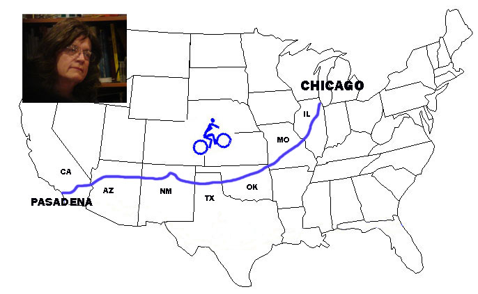
Michael Angerman has completed the map of my journey.  Find it at:  Google Map Link for my ride from Pasadena to Chicago 

Picasso Statue


I wish to thank all of you who followed these blog postings.  Your comments have encouraged me along the way.  

Friday, October 27, 2017

Illinois Bike Trails


Leaves turn yellow along one of the many miles of bike trails in Illinois.  I traveled about half of this state on trails like these.  


Fall colors have not reached their prime yet, but a few cold nights, and mornings of 35 degrees have brightened the trees.  Leaves have done their work, overcome summer, and the struggle has brightened their lives near the end.


Golden leaves
mix with golden sunrise
as fall begins  


Near the north end of Route 66, the people of Illinois remind cyclists that if they follow this trail far enough they will reach Pasadena, California  


Here in Towanda townspeople have placed their bike trail immediately alongside the original Mother Road, saving us the difficulty or riding on its now rough and cracked surface.


They try to maintain the history and culture of
Historic Route 66, with gas stations like this one in Odell.  Trouble is, I remember my father stopping to fill the ’36 Plymouth in one like this when I was barely tall enough to see out the window from the back seat.  No child seats then, or seat belts.


Vermillion River west of Pontiac
Kankakee Ricer at Wilmington


Some rivers are placid like southern bayous.  Some wide and turbulent like in the Rocky Mountains 


I took this picture because it was the only clear sky I saw in three days.


They build elaborate bridges for bicycles over many of the major highways so we don’t have to fight traffic.  And their towns consider the bike path that passes through a feature to build parks and tourist sites around.  


Almost all of the small towns in the gently rolling country of Illinois have a water tower.  It stands on a structure about one hundred feet high.  That’s because 100 feet produces water pressure of 43 pounds per square inch, about the right amount for public water systems.  Each town has its name boldly painted on its water tank to advertise its presence.  All except Atlanta (left), which has a better idea.   


Michael Angerman updates the map of my journey every day.  Find it at:  Google Map Link for my ride from Pasadena to Chicago  

Saturday, October 21, 2017

Perfectly Illinois

:


Through the industrial haze of St. Louis, with its 30 miles of bike-unfriendly traffic, I came from the west, and finally saw the great arch that they  say connects east and west.  


Finally, on a bike path beside the Mississippi River, the arch gleamed above me in the sun.  


I crossed the great river on the old Chain of Rocks Bridge, the way Route 66 crossed from 1936 to 1965.  It’s closed to traffic now except for bikes and pedestrians.  From here, St. Louis fades away.  


Illinois sunrise on my first full day in this bike friendly state.


About half my riding since crossing the Mississippi has been on bike trails like these, completely free from cars.  


It seems odd that the modern idea of bike trails stands right beside a crippled old power line, where rotting poles have splints on their feet to keep from falling and prosthetic arms on their tops to hold up sagging wires. 


Old abandoned Route 66 and the way it looked soon after it opened. 


Even where the bike path is in poor condition, its better than a smooth shoulderless road with too many cars.  And even where I have to nearly stop for heaved up pavement, and a tree seems to say, “Pave over my roots, will you?  Your asphalt is no match,” I can say, “Long live trees.” 


In the little town of Farmersville, they’re having a bake sale to restore the old opera house.  It needs a lot of help, and the cookies were good. 


Michael Angerman updates the map of my journey every day.  Find it at:  Google Map Link for my ride from Pasadena to Chicago  

Wednesday, October 18, 2017

Approaching St. Louis

..


Early morning on a frontage road of I-44, traffic is almost nil, but not the hills.  They come one after another as the sun rises.  It’s an early start into the big city of St. Louis, Missouri.  


It’s still rural with a mix of farmers and big city commuters, as fog rises from a pond, and folks are dressing to feed the cows or drive to their office.


Along this semi-rural road, the natives are being replaced.  They lie beside the pavement, casualties to the spread of humans.


I will try to identify these fallen.  Maybe some of you can help.


Meet Mel, the only long-distance solo cyclist I’ve met on this journey.  She started in Ontario, Canada, and is going to Los Angeles.  She’s 25, starting much younger than I did, and after a month on the road, she seems ready for the journey.  I pushed a little harder and rode happier after meeting her. 


Small towns within commuter’s reach of St. Louis, each with a water tower like its flag.  


While many of the traditional crafts are being gobbled up by the spreading city, a sawmill still makes whisky barrels from white oak logs,  But now they do it in two languages.


Traffic increased and hills got steeper as I approached St. Louis.  Some of the hills were so steep that I got off and pushed the bike.  Even the designated bike routes in this sprawling metropolis have no shoulder or bike lane.  I came to Fenton a suburb of St. Louis and got a motel for two nights.


Michael Angerman updates the map of my journey every day.  Find it at:  Google Map Link for my ride from Pasadena to Chicago